How to Survive Climate Change in the India-Bangladesh Borderlands
The Sundarbans is a region rich in biodiversity. Spread over 10,000 square kilometers in two countries—India and Bangladesh—it is the world’s largest contiguous mangrove forest. The area’s mudflats, forests, river islands, channels, and estuaries are home to more than 1,000 species of plants and animals.
Purno Chandra Mondal, a tourist boat operator who lives in the Sundarbans, is used to highlighting these features to visitors as they float past the area’s lush islands and forests. The fauna include threatened crocodiles, freshwater dolphins, numerous deer, elephants, and the charismatic but deadly royal Bengal tiger. These animals pick their way through needle-like mangrove roots that pop out of the squelchy soft sand of this UNESCO World Heritage site.
But there is another side to the Sundarbans, one Mondal does not share on his tours. More than 4.5 million people live in the region’s forests, waterways, and islands. Of the 102 islands in India’s side of the Sundarbans, for example, 54 are inhabited and have an average population density of 1,000 people per square kilometer.
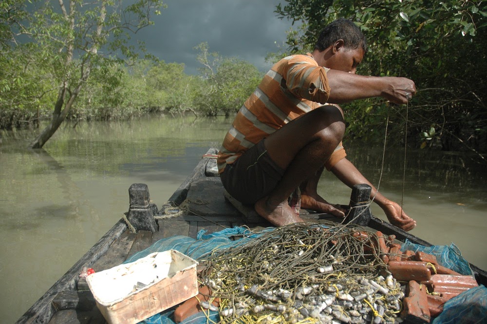
In past generations, Mondal’s family collected crabs in the delta’s canals and estuaries. Others in the region farmed, fished, and harvested honey and shrimp. But conservation efforts, including government legislation in 1972 that barred commercial activity in forest reserves, have shifted the use of these lands and waterways. “People leave the Sundarbans in search of [seasonal] jobs,” Mondal says. “We need to earn money. I don’t want to move, so I have to work really hard, earn well, so that my daughter can attend good schools, study properly.”
Megnaa Mehtta, an environmental anthropologist at the Sheffield Institute for International Development, first met Mondal in 2015 while doing her graduate fieldwork in the area. During Mehtta’s time in the Sundarbans, she listened to many voices like Mondal’s. She learned about their challenges and hopes, the smartphones they wished to buy, the houses they were hoping to build, and their intimate, romantic lives.
Mehtta suspects that the diverse human stories of the Sundarbans, which she has documented, have been eclipsed by the tales of tiger attacks, wildlife under threat, and efforts to preserve the natural beauty in the region. Though all of the environmental stories are important, they neglect the concerns of local people who have also existed in these spaces for years.
The gap in perspectives has become even more obvious as India and Bangladesh find ways to respond to climate change. Each year, bigger cyclones and faster erosion contribute to the loss of dry land in the Sundarbans. Mehtta believes that proposed solutions at the government level, which include the possibility of forcing millions to move elsewhere, reflect the larger failing to consider this region’s human history, current aspirations, and fundamental needs.
“Conversations are mired in what we already know,” says Mehtta as she speaks of the tendency to import conservation and climate resilience strategies from other countries. “There is an urgent need to start putting alternate imaginations into the mainstream.”
Mehtta is one of several scholars who believe there are other approaches possible—provided nations begin listening to the local people along with experts and scholars from the region. Hidden within the stories of Mondal and others living in the Sundarbans, she argues, are lessons about climate resilience that could have global implications.
People have been living in the Sundarbans for centuries. In that time, the landscape has always been unstable: rising tides, storms changing coastlines, and silt reshaping the boundaries of water and land.
“Landmasses in bays and coastal areas have a different relation with water,” says historian Debjani Bhattacharyya, of Drexel University, Mehtta’s long-time collaborator. Land there can regularly appear from and disappear under the waves.
The Sundarbans river system “carries the highest silt load in the world, amounting to about 25 percent of the world total,” write Bhattacharyya and Mehtta in an article published last summer. Rivers carry this sediment into new locations, and in some cases, it collects into mounds that make the land “appear.” Heavy rainfall and swift currents can make them disappear.
Bhattacharyya has studied archival records and noted how, over time, local understandings of this region’s fluctuating landscape were lost or diminished. For instance, prior to the arrival of British colonists, people in this region had laws to settle disputes when land borders changed due to a shifting river.
But, Bhattacharyya says, British colonial administrators looked at land and water as discrete physical and legal entities. They tried to fix land in a fluid landscape.
This response has remained a standard solution in the region to this day. In the process, new social orders linked to the rising waters have developed. Anthropologist Annu Jalais, for example, found that island residents can be divided into three groups based on their distance from the river front. “The largest and most vulnerable group do not own land. They live on the river’s edge and depend on the forest for a living,” Mehtta says. A little further inland, small farmers with less than an acre of land till the soil.
However, the most privileged residents live deep in the island. They find it easier to gradually accumulate wealth because their homes and land aren’t periodically washed away or rendered unusable due to salinity.
Mehtta recounts a conversation with a man she calls Mrinal da— “da” being an honorific in the Bengali language for unrelated older men—who lived in the interior of Bali Island in the Sundarbans. Even after four days of downpour, he looked forward to rain because he collected the water in a pond that he had deepened to irrigate a second harvest of Gobindo Bhog, an expensive variety of freshwater rice.
His experience contrasted sharply with that of the family of crab collectors who were hosting Mehtta. Their home was on a river’s edge. There, Mehtta and her host had to place pots in strategic locations to catch water leaking from the roof.
As rains came, the family hoped that a cyclone or tidal surge wouldn’t threaten their community.
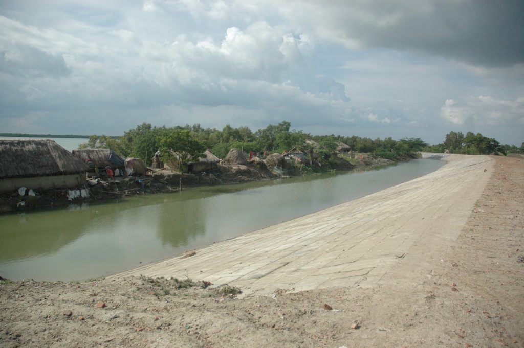
Though the movement of silt and water in the Sundarbans means the landscape is always in flux, climate change has tipped the balance such that erosion is winning out over the process of adding sediment to create land. Administrators have embraced concrete embankments—walls intended to hold back the tide—as a solution.
In 2017, Mehtta met with a senior official in the village administration of Bali Island who wanted to show her a half-finished embankment. She recalls him saying: “Do you know, in the Netherlands, half their country would sink if they didn’t build their embankments? We here in the Sundarbans need to build like them.” (The Netherlands’ renowned system of dikes is considered a model for many nations.)
Construction companies and contractors believe that large embankments in the Sundarbans are architecturally simple structures. Yet in practice embankments can lead to new problems.
As Dilip da Cunha, an architect, planner, and adjunct professor at Columbia University’s Graduate School of Architecture, Planning, and Preservation, puts it, “Embankments create bowls.” The attempt to contain the river, he explains, cuts off the flood plain from the river. Over time, this process increases the height of riverbeds and places a strain on the embankment structure.
During the rainy season, the elevated riverbed worsens the impact of floods. “The Mekong River and the Mississippi are facing similar challenges,” Bhattacharyya adds.
Today the Sundarbans’ embankments are frequently breached in the face of 200-kilometer-per-hour winds and rushing water from the river and sea. When these structures break, they are difficult to repair until after waters recede. As a result, during floods, when residents have the greatest need for hospitals and health care, they are marooned, cut off from essential medical infrastructure.
If people in the Sundarbans are forced to leave, anthropologist Megnaa Mehtta asks, “Where will millions of people suddenly find a place to live?”
In addition, the soft silt of the riverbed cannot bear the weight of cinder blocks from wide concrete embankments. “During Cyclones Aila and Amphan,” Mehtta says, “when the embankments were breached, the mud and silt at their base collapsed and massive chunks of the riverbed went under, eroding the river’s edge.”
Mehtta notes that village administrations have convinced many locals of the advantages of concrete embankments. Mondal, for instance, is in favor. However, in the aftermath of Cyclone Amphan, Mehtta found that some villagers were beginning to observe how concrete causes more damage than older embankment constructions made of mud and bamboo.
Da Cunha and his collaborator, Anuradha Mathur, have studied coastal and river systems around the world. They argue that many designers and architects today perceive rivers and waterways with the idea that land and water can be separated into nonoverlapping entities, as they are on maps. However, da Cunha and Mathur believe these ideas are the product of specific social and cultural worldviews and that other traditions present alternatives to thinking about how people live with water.
Da Cunha and Mathur argue that ancient Egyptian and many ancestral Native American communities lived in ways that acknowledged a continuous presence of waters and wetness. Communities in North America, they explain, lived on raised earth mounds along the Mississippi terraced for farming as the waters receded. When waters rose, the slopes would get submerged without consuming the homes and structures on the top.
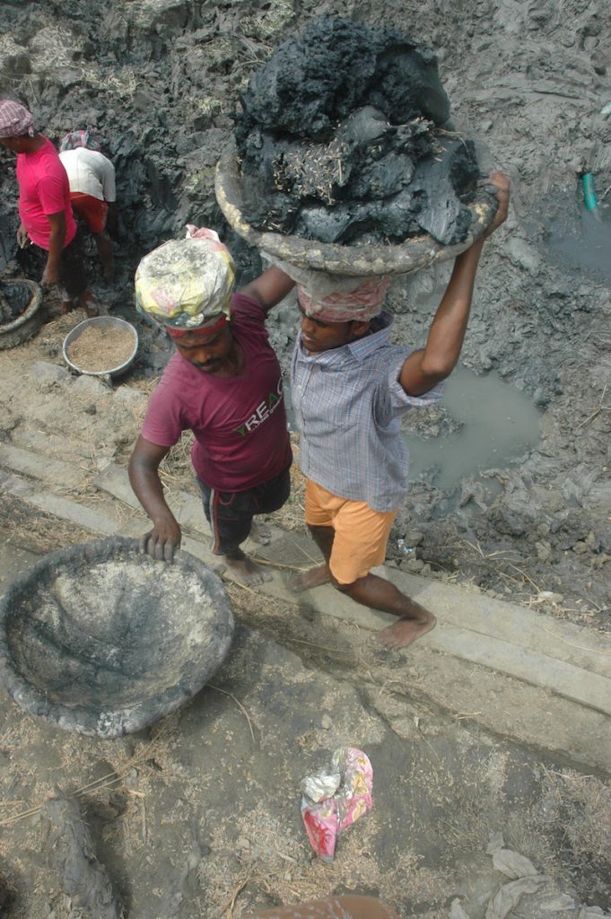
Similarly in the Sundarbans, people traditionally dredged thick, slushy mud from the bottom of a pond over many weeks to build a platform for constructing a home. This work, called mati katar kaaj, meaning “the work of cutting mud,” in Bengali, is back-breaking, expensive labor. But the effort elevated homes and deepened the pond to increase freshwater access.
“We need to rethink who is an expert,” Bhattacharyya says. “Is it the civil engineer who has not formally learned about river systems or the local who is attuned to the mobility of river and water through his language and knowledge systems?”
Bhattacharyya does not dismiss the importance of engineers but fears too often societies may ignore other forms of knowledge. She notes that Bengali has seven words for erosion, for example. One phrase depicts whether the river washed away acres of land in a few minutes (bhanga) and another the slow erosion caused by bubbling waters (bhurbhuri bhanga). The terms “erosion” and “deposition,” she argues, are too limiting to understand the extent of the interactions, drawing attention to the various kinds of expertise that are needed to build climate-resilient structures.
After an embankment fails, the strategy of managed retreat—sending people out of the region—gains traction among policymakers. The approach seems like a prudent alternative to the humanitarian disaster of people trapped without access to hospitals or other infrastructure after storms.
But Mehtta is skeptical. “Planned relocation only works when there is a particular kind of relationship between the state and its citizens,” she says, referring to models like the Dutch-managed retreat.
There is no social security net for the people of the Sundarbans if they are asked to leave the land. “Where are they going to go?” Mehtta asks. “Where will millions of people suddenly find a place to live?”
In addition, residents of the Sundarbans have intergenerational trauma from violent relocations in the past, even before climate change began to force migrations. “It is difficult to forget incidents like [the] Marichjhapi massacre,” says Bhattacharyya, recalling a violent clash between refugees on an island in the Sundarbans and the police in 1979.
Mehtta wonders whether some of the millions of dollars dedicated to embankments couldn’t be redirected toward more locally driven solutions. For example, funding could revive ecologically appropriate crops like salt-resistant varieties of rice and help build land and mobile hospitals on boats, as has been done in other parts of the world. Another government scheme already supports constructing affordable housing in India; modifying that program could incentivize building traditional raised-platform houses in the Sundarbans.
“I am not recommending any one approach as a silver bullet,” Mehtta insists. Instead, she is pushing to tailor solutions in each instance. “Climate change is going to affect diverse communities across the world. We need to start using bottom-up approaches—start from people, their desires and aspirations, understand their knowledge, and then try to find solutions.”
Mehtta has witnessed an enormous commitment to conservation in the Sundarbans. “If this is possible for tigers,” she asks, “can we not find creative ways of people here living fuller existences?”
Mondal is one of many people in the Sundarbans who worries about how and if future generations will survive in the region. He recognizes migration as a reality—driven less so by rising waters than by a lack of jobs and state services. Bottom-up thinking, as Mehtta describes, could help empower the region’s people.
“I don’t want to leave the Sundarbans,” Mondal says. However, he would like his 2-year-old daughter to grow up with the choice to stay or leave, not driven out by necessity.


